


NOVEL UDAR WORKFLOW COMBINING 3D RESERVOIR MAPPING WITH RESISTIVITY RANGING WHILE-DRILLING
Downtown Houston
Speaker:
Seminar Date: Oct 15 2026
Registration Opens: Sep 01 2026 - Sep 14 2026
Time: 11:30 AM - 01:00 PM (US CDT)
Admission/Registration Link: None
Donation Link: Donate Here
Meeting/Webinar Link: None
Contact: Andrew Hind (VP Downtown, SPWLA Houston Chapter)
Corresponding: vpdowntown@spwla-houston.org
Fees:For Student: $5
For Member: $5
For Non-member: $5
NOTES:
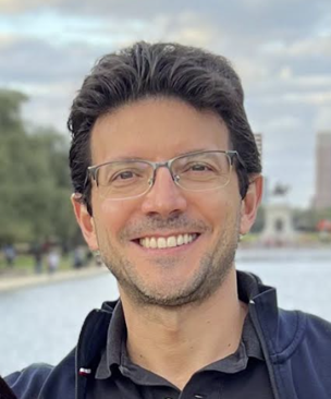
Speaker: Diogo Salim, Reservoir Mapping Integration Group Lead,
SLB
🗓 Date: October 15th
of 2026.
🕦 Time: 11:30 AM – 1:00
PM (US Central Time)
📍 Location: 2000 West
Loop South, Lobby Conference Room, Houston, TX 77027
🎟️ Admission: $5 + $4 Parking
Host: Andrew Hind vpdowntown spwla-houston.org
ABSTRACT:
As additional boreholes are drilled in congested oilfields, the presence of nearby wells containing metallic object (e.g., casing or screens) can become a challenge for the successful well construction, especially for infill wells or sidetracks, given its major drilling risks of potential collision events. Moreover, depending on the distance among the nearby wells and the new borehole, such metallic objects can directly interfere in the UDAR measurements causing significant impairment to the inversion results. This talk describes a novel modelling approach that can determine and measure the metallic effects on the EM measurements for every frequency and spacing of the UDAR tool. Furthermore, the high sensitivity of UDAR measurements to nearby metallic objects enabled a new well-ranging-while-drilling solution, which delivers in real time both relative distance and azimuthal direction of the target well. It can potentially provide various ranging applications, including collision avoidance, well twinning, and well interception during drilling operations. The novel solution was deployed in a real offshore case with the goal to determine the effects on UDAR measurements caused by a metallic screen of a nearby well during drilling of a sidetrack. In the pre-job stage, a 3D finite-element modelling estimated the safe distance from metallic interference for each UDAR spacing and frequency. Then during operation, it was observed within the predicted interval and substantiated by presence of artifacts in the resistivity inversion. Additionally, the ranging workflow was tested while-drilling and effectively determined the distance and azimuthal direction of the adjacent well. The new workflow was applied using each transmitter-receiver (Tx-Rx) spacing independently with the objective of enabling a multi-depth ranging detection. Finally, this innovative approach expands the current geosteering modelling and applications by simultaneously mapping the subsurface formation and ranging the downhole metallic objects.
BIOGRAPHY:
Diogo Salim is the Reservoir Mapping Integration Group (RMIG) Lead in the SLB Engineering department of Houston Formation Evaluation (HFE), based in Sugar Land, Texas - USA. He is currently working on novel LWD technologies and digital applications in the domain of geosteering and reservoir mapping, well ranging and reservoir characterization while drilling. He is a Principal petro-technical expert, who joined SLB in 2004 and has worked in the wireline and drilling areas holding various job positions across research, engineering, all the way to operations. He received an MSc. degree in Petroleum Engineering from Federal University of Rio de Janeiro (Brazil) with emphasis on reservoir engineering and numerical simulation. He has contributed to various patent applications and authored/co-authored nearly 50 papers and articles in different professional societies and external conferences in the energy industry.